There are a number of interesting features you can find in the Great Wood. This is an introduction to some of them.
The ancient beeches
Close to the picnic area are two ancient beeches, the girth of which suggests that they predate the commercial exploitation of the wood in the 19th century and are survivors of the original woodland of the 18th century. Sadly, the right hand tree is now dead and its branches removed. Click on the 1st photo to see a map of their location.


Glades
There are several natural glades in the wood and some which have additionally been cleared to replicate more closely the original wood pasture common of the area. Again, click on the photo to see the location of the main glades.

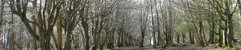
The Hornbeam Pollards
Along the boundary with the County School Camp, there is a line of closely-planted Hornbeams, probably dating from the division of the land in 1811. Over the years, these had been both coppiced and pollarded, but in recent times no management had been done and the row had become overgrown, causing the area to be dark in summer due to the dense canopy, which in turn meant the path stayed very muddy. Only in winter could the line of trees be properly appreciated, see below. Click on the photo for the location.
 The council reviewed what management should be attempted on the line and came to the view that the original dense planting was probably meant to create a laid hedge, but no laying was ever done. So in 2011, a start was made on thinning the trees and creating a laid hedge – not an easy task with mature trees.
Initially the view was very stark but now (2018) the hedge has developed into dense bushes and further sections have been processed. So now, the view above and that used on our site banner is no longer possible.

View in 2011 above and 2018 below.

 This 2018 view shows ‘before and after’.
When walking this section of the Yellow trail do look out for the Hornbeam pollards in the camp area itself. Over the years, these have been subject to much more traditional pollarding and are quite spectacular.
The Swallowholes
Where the geological layer known as ‘Reading Beds’ are shallow, such as near Cuffley Brook, acidic water has created subterranean passages through the underlying chalk – some may extend for many miles. This leaves characteristic ‘craters’, some of which are now dry but some still show the drain holes. Click on the photo for their location.

The old Parish Boundary
Just to the north of Cuffley Brook you can just make out a raised mossy bank running alongside the Brook. This is the original boundary line between Northaw and Hatfield Parishes and may have once had a fence along it. Click photo for location.
The Concrete Path
The entrance to the Great Wood in Carbone Hill is a concrete path, now much overgrown by nature and time. It was built during the Second World War to access an Anti-Aircraft position and features a number of tank traps, a remnant of the Outer London Stop Line, intended as the final defensive position for London should an invasion have occurred. Click on the 1st picture for a wartime map (look out for the River Somme!) and the 2nd picture for the location of the path.

